|
for Urban Sustainability |
 |




The Analytical Framework |
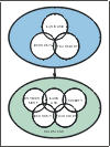
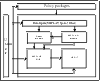
The goal of the SPARTACUS project was to develop, and subsequently pilot the use of a comprehensive analytical framework for building and evaluating long term strategies for sustainable urban development including its social, economic and environmental aspects. In practice, the development of the analytical framework for SPARTACUS has depended upon the integration of a new set of analytical tools with existing simulation modelling facilities provided by the MEPLAN system. The basic idea is shown in Figure 1 and the final design is shown in Figure 2 and is the result of an iterative process which reflects the evolution of the Consortium’s ideas for the overall project.
New modules have been developed during the project in order to be able to calculate values for urban sustainability indicators and background variables which illustrate the results and evaluate the effects of policy options. The main components of the system divide broadly into four: (i) The SPARTACUS "engine"—this incorporates the modelling tools, MEPLAN and the Raster Module and is where the policy simulation and much of the basic mathematical computation is carried out. MEPLAN is a computer software package based on a land-use transport interaction modelling framework. The RASTER module is a GIS-based method to calculate indicator values that must be treated in a spatially disaggregated way. For the purposes of the module, each test city has been rasterised, i.e. divided into a grid of 100m x 100m cells. The Raster module uses zonal and link-based outputs from the MEPLAN model, disaggregates it, applies grid-based analytical and dispersion models for assessing environmental and social impacts and aggregates the results as indicators. (ii) A set of input files which provides data to the models and incorporates facilities for translating policy packages into a form suitable for model simulation. (iii) An integrated GIS (MEPLUS) module which provides tools for policy analysis and reporting of results. This includes facilities for storing, manipulating and screen-browsing of selected model outputs and calculation of indicators and background variables based on the output of MEPLAN and Raster. (iv) The indicators are further processed in the USE-IT (Urban Sustainability Evaluation and Interpretation Tool) module. USE-IT is an independent decision support tool allowing the user to define indicators, give weights and value functions for the indicators in order to calculate sustainability indices and to view results in tables or in graphical forms. In SPARTACUS, USE-IT is interfaced with the RASTER and MEPLUS modules. Special features include the choice of different theories of justice that are used in calculating some of the social indicators and consistency checks that are used when weights are given for the indicators. Figure 2-5 also illustrates the main flows of information within the system:
|